There are four elements to the map:
- the map itself that renders the weather data
- the "Map Data Details" at the top of the map
- the "Map Controls" at the bottom of the map
- the "Scalebar" below the controls.
Tip
Tap on the clock icon to snap to the current time.
Map Gestures
Time Swiping
One-finger swipe to change the time:
- horizontal swiping will control a fast change in time.
- vertical swiping will control a slow change in time.
Zooming
Two-finger pinch to zoom in and out.
Panning
Two-finger swipe to pan to another location:
- Flowx will show data for the panned location.
- You can select "Add Place" in the side menu to add the panned location as a new place.
- You can select "Set Place" in the top-right menu to replace the previously selected place with the panned location.
Editing Data Types
To add/remove a data type to the map data menu, or rearrange the order of the menu, click the + symbol on the right hand side.
- Select: select the data types required
- Order: drag-and-drop to rearrange the order
Editing Data Layers and Spectrums
If you long-press on the scalebar, a dialog will popup to allow you to edit the data layer and spectrum.
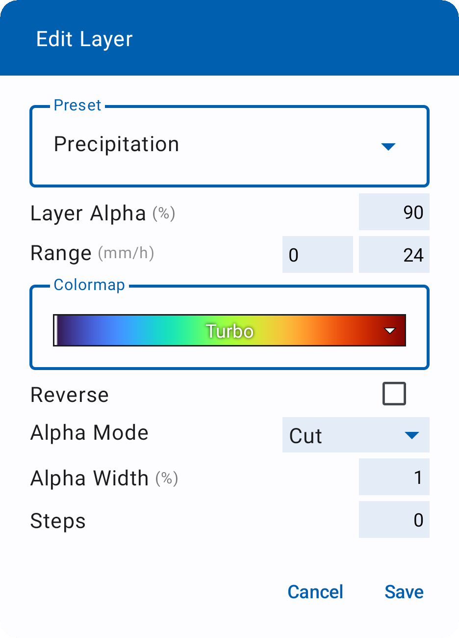
You can select the spectrum preset at the top of the dialog. It is important to understand that this will set the spectrum preset for the data type (e.g., precipitation or temperature) for the current selected place. In other words, you can set the temperature preset for a cold location to "Temperature Frigid" and for a warmer location to "Temperature Temperate".
However, when you edit a configuration of a spectrum preset, this will apply to all places that use that spectrum preset.
You can edit the following settings for a preset:
- Layer Alpha or Opacity: set the transparency of the layer.
- Range: set the minimum and maximum values for the scale. If the value is left blank, it will default to the minimum or maximum value of the data in the view.
- Colors: set the colormap for the spectrum.
- Reverse: reverses the colormap.
- Alpha Mode: sets the type of alpha region at the start or end of the colormap. This is useful for data where values above or below a certain amount should not be rendered on the map.
- None - no alpha region is drawn
- Cut - sets the alpha region to be fully transparent
- Ramp - linearly increases the transparency of the alpha region.
- Alpha Width: will set the size of the alpha region. A negative value will create the alpha region at the end of the spectrum.
- Steps: this will discretize the colormap into discrete steps. If set blank or "0", will lead to a smooth colormap.
Editing Gauges
To edit the gauges bar at the top of the map, long-press on an icon and select add or delete. Note: The default gauges when the app is installed are: time, temperature, precipitation and wind vectors.